Bermuda Island Latitude=
32.2N
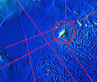
Extensive Analysis of 3D topographic ocean seafloor maps reveals an incredible coincidence. Trench-like features that are in straight lines reveal a relationship that is far-reaching in possible implications. A few of these trench-like features extend for many miles, in some places they extend on the surface of the ocean floor for hundreds of miles. The
Bermuda Island can be seen below, along with several lines, some that seem
to come to or end
Below is the Bermuda Area above with red lines overlapping the 'trench-like' features: The trenches above are particularly fascinating because sometimes they lead to areas that contain mountain like features on the ocean floor and sometimes these features can be seen on the surface of the land. Some of these mountain like features resemble pyramidal shapes that are extremely large in scale.
|
||